Management of Greenways
Greenways Management
The Greenways are managed through the s.355 Greenways Management Committee (see more below) of the Queanbeyan-Palerang Regional Council (QPRC).
Principles for management of the Greenways
- Environmental protection is to be observed in relation to the management and administration of the Greenways;
- The Greenways (both the land and its other resources) are to be used and managed in a sustainable manner;
- Safe and diverse (non-motorised) uses and enjoyment of the greenways are tobe encouraged, and;
- The Greenways are to be maintained in as natural state as possible.
Objectives of the Greenways Master Plan and Strategy
The primary objective of the Master Plan is to provide a 10-year strategy for the development an maintenance of the Bywong/Wamboin Greenways network, to be reviewed by the s.355 Committee on a regular basis.
Other objectives are:
a) to provide and maintain the amenity of the Greenways for the enjoyment of the community
b) to raise public awareness of the importance of the Greenways and to encourage community participation in
i) any actions recommended in implementing the Greenways development and management strategy
ii) use of the Greenways in accordance with their strategic objectives
c) to minimise the effect of soil erosion that might arise from usage
d) to encourage and otherwise ensure the conservation of natural flora and fauna
e) to monitor and control the introduction and spread of weeds
f) to protect all waterways, ephemeral or permanent
g) to protect all identified significant areas or sites, whether environmental or cultural e.g. culturally modified trees.
Bywong/Wamboin Greenways Master Plan 2024
Further to community consultation on a Draft, the Bywong/Wamboin Greenways Master Plan was submitted to, and endorsed by, Council in late 2024.
The Greenways Master Plan 2024 contains a map of the Bywong/Wamboin Greenways network together with a code and an identifier for all links forming the network. A downloadable and foldable Greenways Brochure contains a copy of the Greenways map (below).
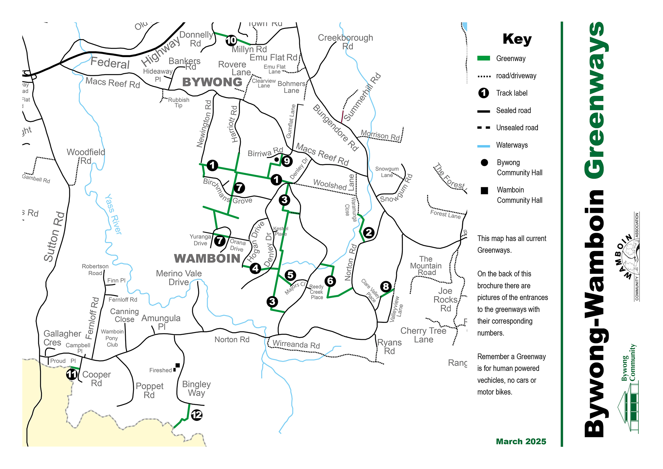
Greenways are marked on the QPRC cadastral map, and the segments are labelled as below, commencing at section 1/segment 1a and ending at section 12.
| Greenway Section | ID | Segment |
|---|---|---|
| Extension to Newington Road (to be deleted as has now been developed as a road) | 1 | 1a |
| Newington Road to end of Harriet Rd extension | 1 | 1b |
| End Birchmans Grove to Newington Road | 1 | 1c |
| Harriott Road extension | 1 | d |
| Harriott Road extension to T-junction | 1 | e |
| T-junction to Denley Drive | 1 | f |
| Warramunga Close to Norton Road | 2 | 2a/2b/2c |
| Denley Drive to back of 441 Weerona Drive | 3 | 3a |
| Beside 441 WeeronaDrive | 3 | 3b |
| Back of 441 Weerona Drive to Weerona Drive South | 3 | 3c/3d/3e/3f |
| Hogan Drive to Millpost Hill | 4 | 4a |
| Millpost Hill | 4 | |
| Millpost Hill to Denley Drive | 4 | 4b |
| Denley to Greenway 3 | 4 | 4c |
| Greenway 3 to Majors Close | 5 | 5 |
| 254 Weerona Srive to 1203 Norton Road | 6 | 6a/6b/6c |
| End Harriott Road extension to Birchmans Grove | 7 | 7a |
| Birchmans Grove to Yurunga Drive | 7 | 7b/7c/7d |
| Yuranga Drive to Yuranga Drive post community bore | 7 | 7e |
| Clare Valley Place to Valley View Lane | 8 | 8 |
| Birriwa Road to back of Les Reardon Reserve | 9 | 9a |
| Les Reardon Reserve to T-junction | 9 | 9b |
| Millynn Road to Donnelly Road (middle section) | 10 | |
| Cooper Road to Kowen Forest | 11 | |
| Bingley Way to forest (road) | 12 | 12a |
| Forest to ACT border | 12 | 12b |
_____________________________________________________
Earlier versions of the Master Plan are:
Greenways Master Plan (Version 1.1) (2018)
Greenways Master Plan (Version 1.2) (2020)
s.355 Greenways Management Committee
The Committee comprises representatives of the primary Greenways user groups and arranges necessary maintenance works in association with Council staff and periodic working bees that are supported by voluntary labour provided by local residents.
The Committee can be contacted via greenwayscommittee@gmail.com.
All Greenways website pages are maintained by the Greenways Management Committee.
Last updated 21 March 2025.