Maps and Walks
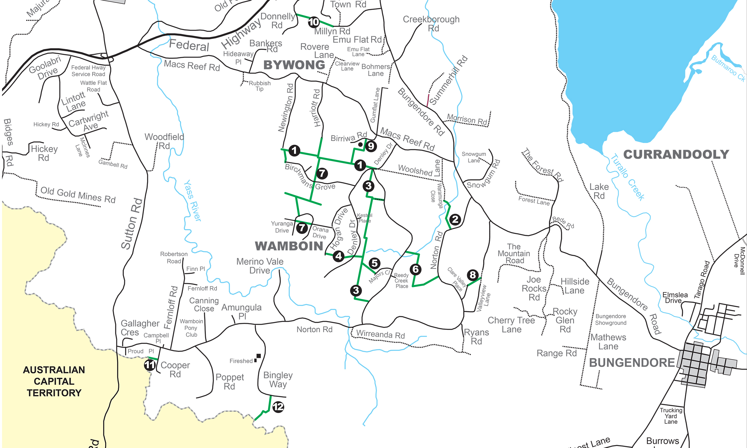
General Area Map
The Greenways of Bywong and Wamboin are located in the area East of the Federal Highway, West of Bungendore and North of the New South Wales/Australian Capital Territory border (see map below).
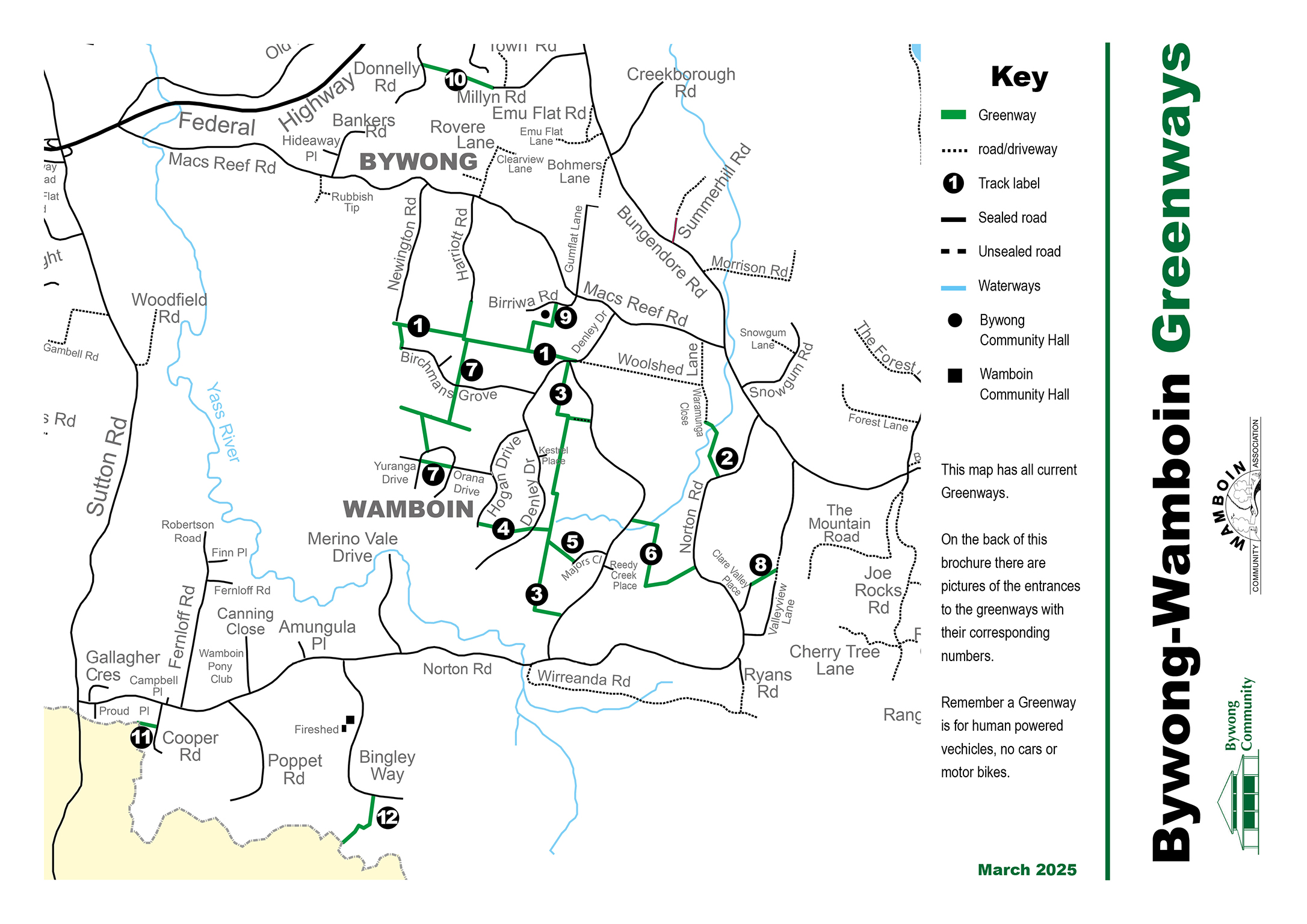
Greenways Network Map
12 Walks with Google Maps & Printable Maps
The 12 walks listed here are a mix of loop walks and A-B /return walks. They are listed in order of shortest to longest distance. REMEMBER the two biggest safety issues while out walking will be fast moving vehicles, and snakes, in that order.
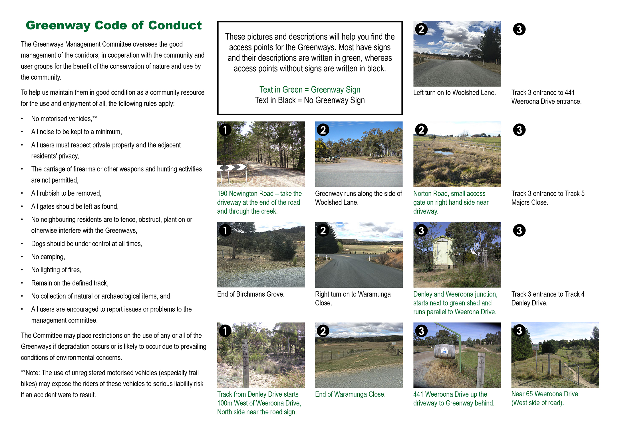
Maps Legend- What do the icons mean?
![]()
DOWNLOAD PRINTABLE table of walks: WALK map table for website 30 May 2022
| WALK No. | DISTANCE & TYPE | TERRAIN & SEASON | MAP & DETAILS |
|---|---|---|---|
| 1 | 1.4kms about 20-25 mins approx. A-B walk / return | Undulating walk with one very small uphill and downhill. SPRING, AUTUMN, WINTER. | Bywong Hall- short orientation walk for those new to greenways to show them how to access the greenways from Jx Les Reardon Reserve to South to Jx Bywong Hall (Cresswell’s corner) return. GOOGLE MAP TRACK NOTES : Mel Hillery has produced these lovely track notes, giving some additional information about the local flowers and other natural attractions for this walk- Nature Notes Track 1 Nature Notes Track 1 |
| 2 | 2.5kms- 1 hour very leisurely. A-B walk return | Flat, easy walking. Minimal shade. SPRING, AUTUMN, WINTER. | Lake George/ Ngungara lakeside SHORT WALK– stroll along the Lakeshore and admire the view. Two walk options that lend an appreciation to the South Western view of Lake George/ Weereewa or Ngungara. Option 1 is a short walk along the foreshore from the car park below the viewing lookout. Option 2 is a walk from the viewing lookout heading South, up the ridge and through a gate. This is private land. Continue South along the escarpment until you reach a fenceline. This land is crown land, and you should request permission to access from the lease holder, Shaun Read 0428 572 061. Continue South and head downhill a little until you come to a cluster of trees with a really good view South to Bungendore and East across to the wind turbines. GOOGLE MAP |
| 3 | 3.26 kms: 1 hour approx. LOOP Walk | 3 small hills, bushland and very scrubby underfoot, long grass. SUMMER: Shady | Clare Lane, Valley & Valley View Lane LOOP WALK: - either direction. Starting from EntExClare Lane. head South to the Jx Valley View, West up the hill and down to EntEx Clare Valley Lane, then South West along the roadside to Norton Road, take the path on the East side of Norton Road, and then turn North onto Valley View Lane roadside and to the cul-de-sac. Straight through the EntExt Valley View gate and back to EntEx Clare Lane. GOOGLE MAP |
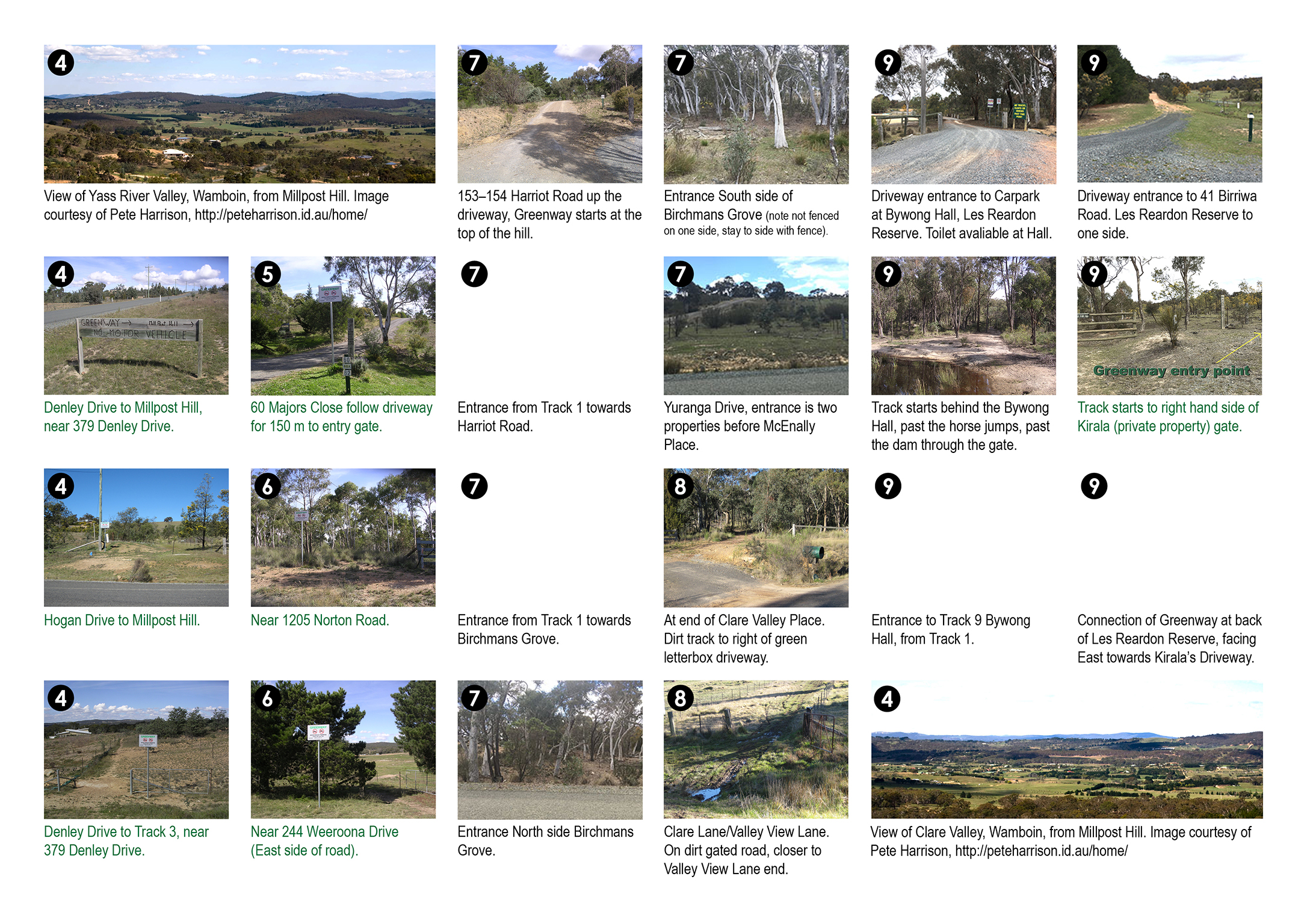
| 4 | 3.6kms about 1-1 ½hours. LOOP Walk. | Mostly flat, some undulating walking. Mostly on clear path aside from roadside walking on Denley and Macs Reef. SPRING, AUTUMN, WINTER. | Bywong Hall / Macs Reef Loop: Bywong Hall/ Les Reardon Reserve: ANTI-CLOCKWISE LOOP: Head South to Jx Bywong Hall, then go West to EntEx 46-136 Denley Drive, then North along Denley Drive to Macs Reef Road. Head West along Macs Reef Road (North side mostly) down hill to Birriwa Road and return to the Hall. GOOGLE MAP |
| 5 | 8.7 kms About 2-3 hours LOOP walk Car shuffle | Flat and mostly clear paths. SUMMER, SPRING, AUTUMN- Mostly shaded walking. | Weeroona Drive to Clare Lane LOOP Walk: Walking from West to East: Start at Weeroona Drive entrance walking east along an open paddock, cross an eroded creek bed into a line of pine trees. Follow the path to the corner Cnr Weeroona/Norton and head South into remnant bush. Follow the path that leads South into an open paddock just before the Cnr Norton/Weeroona and then head West along the fence line, through a small creek and up the hill towards EntEx 1199- 1205 Norton Road. Head South along Norton roadside and cross the road when you get to Clare Valley Place. Walk to the end at the cul-de-sac to join the greenway EntEx 48-50 Clare Valley Place, up and over the small hill down towards a gate (Cnr Valley View). OPTION TO walk North out to Clare Lane OR Head South in a loop to Valley View Lane, through the gate near the cul-de-sac and along the road to Norton Road. Head North along Norton Road on the track on the East side of the road, past the Clare Valley Place junction until you get back to EntEx 1199- 1205 Norton Road. Back on to the greenway to Weeroona Drive. GOOGLE MAP |
| 6 | 4.4kms 1 - 1 1/2 hour faster pace. LOOP WALK | More difficult- Flat walking combined with some short, steep climbing with a return the same way. SPRING, AUTUMN, WINTER- Minimal shade. Very pleasant when no Westerly wind blowing with traffic noise from Highway. | Lake George/ Ngungara / Crown land LOOP walk: Start at Weereewa Lookout car park. Jump fence and head south up the escarpment to the gate. Continue South along the escarpment (private land) and walk past the tower onto crown land. Continue South just before a large gully, to admire the view South to Bungendore and out to the East. Traverse along the escarpment heading North. GOOGLE MAP |
| 7 | 6 kms- 1 ½- 2 hours fairly leisurely pace. LOOP WALK | Mixed terrain – mostly flat, some short steep hills. SPRING, AUTUMN, WINTER. Only shade is along Macs Reef roadside and western corner of Newington Road. | Harriott Road/ Newington Road LOOP: Start anywhere along the Harriott/ Macs Reef corners/ Newington road. Access the greenway at the Southern end of the loop from either EntEx 152-154 Harriott or EntEx 197 Newington. GOOGLE MAP |
| 8 | 6.4 kms- 1 ½- 2 hours fairly leisurely pace. A-B walk Car shuffle | Mostly flat and downhill from Millyn to The Henge. Mixed paths- Donnelly Links have no made path. SPRING, SUMMER, AUTUMN, WINTER. | Millyn Road to South End Old Federal Highway: either direction. From Millyn road to Donnelly Road, walk Donnelly Road down to the new Fed Hwy to Old Federal Highway. Downhill finish with visit to either Tulip Top Gardens (open September-October) or across the highway to The Henge (private facility). Walking the other direction will be primarily uphill. GOOGLE MAP |
| 9 | 7kms – 1 ½ -2 hours walk. LOOP WALK | Mostly flat, one short steep hill. Rough terrain in parts along Federal Highway, and some parts of Schofield road, including fording a creek, and some parts of Donnelly links. Take care on Bungendore Road section – traffic. AUTUMN, WINTER, SPRING | Donnelly Links/ Fed Highway/ Schofield Road/ Bungendore Road/ Millyn Road LOOP either direction. This walk offers a variety of views, and is mostly only slightly undulating, except the the Easterly section of road adjoining Bungendore Road where there is a hill. A few challenges - jump one fence at Donnelly Road/ Fed Highway section, wading through very boggy ankle-deep water in one section of the Schofield Road. Take care walking alongside the Bungendore Road - not very long but quite narrow. Millyn Road walking is delightful. The Donnelly Links have a series of unlocked gates for through access. GOOGLE MAP |
| 10 | 11kms approx 2- 3 hours walk. LOOP WALK | Mixed terrain – mostly flat, some short steep hills. SPRING, SUMMER, AUTUMN, WINTER. Shaded along greenways and open no shade along paved roads and Millpost Hill. | Millpost Hill LOOP – either direction OPTION 1 - Anticlockwise from Bywong Hall . West and then South through Birchmans Grove to Orana Drive, Hogan Drive up to Millpost and down the other side crossing Denley to meet the Greenways heading North and back to Bywong Hall. OPTION 2 - Clockwise from Majors Close. Majors Close head West to Millpost Hill, North on Hogan Drive, West to Orana & Yuranga, north onto greenway towards Birchmans Grove and Jx Harriott. Head East towards Denley Drive, across Denley to enter greenway and head South back to Majors Close. GOOGLE MAP |
| 11 | 13kms 3-4 hours walk. LOOP WALK | Mostly flat and mostly clear paths. SPRING, AUTUMN, WINTER- No shade on Eastern end of Woolshed Lane, Warramunga Lane, greenway link between Warramunga/ Norton and along Norton Rd. | Woolshed/ Warramunga/ Norton/ Weeroona LOOP Walk. Start anywhere along the loop, heading either way. Clockwise walk - Walk the length of Woolshed Lane, the length of Warramunga Close, the Warramunga/ Norton Road greenway, Norton Road northern section, Norton Road/ Weeroona Drive greenway, Weeroona Drive to Majors Close cul-de-sac, EntEx Majors Close to Jx Majors all the way North to EntEx 97 Denley Drive. GOOGLE MAP |
| 12 | 14.6km 3-5 hours walk LOOP WALK | Mostly flat and mostly clear paths and roadside walking. AUTUMN, WINTER, SPRING. Northern section is mostly shaded with the southern section being open and exposed. SUMMER option could include walking Norton Road rather than Wirreanda Road. | Wamboin Loop Walk – start anywhere on the loop. CLOCKWISE DIRECTION: Incorporates existing greenways network off Weeroona Drive, connecting with Norton Road and then to Ryans Road, Wirreanda Road, back to Norton Road and Weeroona Drive. GOOGLE MAP |
Roadside Access Ways
Bywong & Wamboin greenways are linked to local roads. Many of these local roads have unpaved walk access alongside the road, including a number of our main roads.
Macs Reef Road – Google map with where roadside access is safe.
Geocaching
If you are into Geocaching there are a number located in Bywong and Wamboin areas on Greenways, there are even some Trig point caches too. A simple Internet search with… Bywong, Wamboin and geocache… will find a number of them.
Public Walks
The Greenways network is accessible at any time, and people can be seen enjoying the Greenways every day of the year, and throughout the day.
Organised walks are currently conducted on an ad hoc basis, usually lead by a Member of the Greenways Management Committee or someone else with knowledge of the history and/or natural environment of the area. Planned walks are advertised well in advance via the local newspapers and Facebook groups.
For planned walks starting or ending at the Bywong Community Hall morning tea, lunch or afternoon tea is often part of the plan.
Instructions to view the Greenways Network via Online Mapping
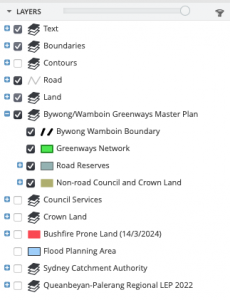
On opening Online Mapping-Queanbeyan-Palerang scroll down and select “Start Online Mapping”. Accept the disclaimer and then select “Continue”. In the Menu on the left, under LAYERS select the + sign and the box next to Bywong/Wamboin Greenways Master Plan and the menu will be expanded as in the diagram below.
A map of the QPRC area will be displayed. Zoom in using the + button at the top left of the map. Alternatively select ROAD NAME below the map and type a road name (eg Weeroona Drive) and hit Search. Then zoom in. If you zoom in enough, you can see the Greenway segment numbers. You can move the map around with your mouse.
Mobile Phone – You can also do this on a mobile phone. Hit the LAYERS icon at the bottom of the screen, then scroll down to Bywong/Wamboin Greenways Master Plan and select it. Then hit the magnifying glass (Search icon), select a Road Name, then an icon with 4 arrows. Then the map will appear.
This page is maintained by the Greenways Management Committee. Comments and suggestions for improvements to greenwayscommittee@gmail.com are welcomed.
Last updated 20 March 2025.